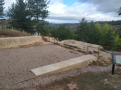
Iglesia Ruinas de la iglesia de San Martín de la Cuesta
Dirección
42004 Soria
Ciudad : Soria Soria
website :
Telf :
email : –
Pag. web en google Maps :https://goo.gl/maps/jmXyXyTYeeRHBBvT7
Valoración por los usuarios de google maps : 3,0
Numero de opiniones usuarios de google maps :1
Opiniones de los usuarios de google maps :
Turista Inglesa (3)
(Traducido por Google) Una pausa agradable en el camino de regreso al Parador, y un panel de información interesante para leer, aunque no hay mucho más que ver aquí, excepto algunos pequeños trozos de paredes. Pero continúan sus excavaciones y esperan encontrar más.
Se cree que es, no están muy seguros, todo lo que queda de la iglesia de San Martín, una iglesia pequeña de estilo normando (es decir, arquitectura románica) construida a mediados del siglo XII, que luego cayó en ruinas y desapareció bajo los arbustos. y árboles en el siglo XVIII.
Los restos fueron encontrados por accidente a principios del siglo XX cuando estaban rehaciendo la denominada «Carretera de las siete curvas», la serpenteante carretera que sube al Parque del Castillo y al Parador.
Esta vía tiene a su lado, y normalmente apenas visible desde el coche, un amplio malecón que va desde lo alto del parque hasta el río Duero, haciendo un camino peatonal muy agradable hacia los paseos ribereños.
¡Y, por supuesto, a estos restos!
(Original)
A pleasant pause on your way back up the road to the Parador, and an interesting information panel to read, although there$0027s nothing much else to see here except some tiny bits of walls. But they are continuing their excavations, and hope to find more.
It is believed to be, they are not quite sure, all that is left of the church of Saint Martin, a Norman-style (i.e. Romanesque architecture) smallish church built in the mid-12th century, later falling into ruins and disappearing under shrubs and trees by the 18th century.
The remains were found by accident early in the 20th century when they were remaking the so-called «Road of the seven curves», the wiggly road that leads up to the Parque del Castillo and the Parador.
This road has by its side, and usually hardly visible from your car, a wide boardwalk going all the way from the top of the park down to the Duero river, making a very pleasant pedestrian way to the riverside walks.
And, of course, to these remains!
Horario y dias de apertura :
En el mapa pulse : Como llegar , para que el mapa le muestre el camino , desde su ubicación a la parroquia
ver el mapa en otra pagina pulse aqui .
Vea iglesias en esta provincia .
Vea iglesias en esta localidad .